
Photo spots
Photo spots in Boston: the 2026 list
20 landmarks ranked by how many different people photographed them.
The most photographed place inside Boston city limits on Wikimedia Commons is Fenway Park, with geotagged photos from 58 different photographers. This guide ranks 20 landmarks by how many different people photographed them, with a credited sample photo, the hours most photos were taken and the official site where one exists.
Updated November 2026
The 20 most photographed places in Boston
Ranked by distinct photographers on Wikimedia Commons. Sample photos are credited to their authors.
The busiest hours below come from the cameras' own clocks.

#1
Fenway Park
58 photographers · 398 geotagged photos
Run by Fenway Sports Group.
Photo: Gatorfan252525 · CC BY-SA 4.0

#2
Boston Public Garden
53 photographers · 246 geotagged photos
Most photos here were taken from 9 AM to 12 PM (35% of 233 dated photos).
Photo: Christian David · CC BY-SA 4.0

#3
Boston Common
48 photographers · 281 geotagged photos
Most photos here were taken from 2 PM to 5 PM (45% of 273 dated photos).
Photo: Phillip Capper from Wellington, New Zealand · CC BY 2.0

#4
Old State House
36 photographers · 135 geotagged photos
Most photos here were taken from 11 AM to 2 PM (52% of 127 dated photos).
Photo: Daniel Schwen · CC BY-SA 2.5
#5
Copley Square
35 photographers · 293 geotagged photos
Most photos here were taken from 11 AM to 2 PM (50% of 282 dated photos).
Photo: Eos12 · Public domain
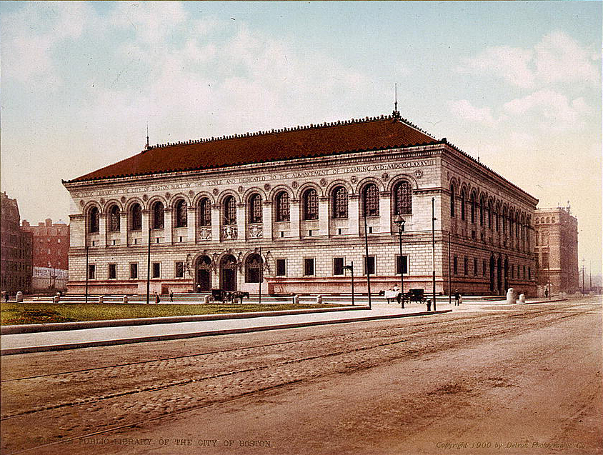
#6
Boston Public Library, McKim Building
34 photographers · 158 geotagged photos
Most photos here were taken from 12 PM to 3 PM (43% of 154 dated photos).
Photo: Dogears · Public domain

#7
One Boston Place
32 photographers · 176 geotagged photos
Most photos here were taken from 11 AM to 2 PM (70% of 168 dated photos).
Photo: Terageorge · CC BY-SA 4.0

#8
South Station
30 photographers · 207 geotagged photos
Most photos here were taken from 12 PM to 3 PM (33% of 203 dated photos).
Photo: ArnoldReinhold · CC BY-SA 3.0

#9
Massachusetts State House
28 photographers · 85 geotagged photos
Most photos here were taken from 11 AM to 2 PM (53% of 83 dated photos).
Photo: Christian David · CC BY-SA 4.0

#10
Trinity Church
26 photographers · 67 geotagged photos
Most photos here were taken from 2 PM to 5 PM (39% of 66 dated photos).
Photo: Daderot at English Wikipedia · CC BY-SA 3.0

#11
Freedom Trail
25 photographers · 59 geotagged photos
Most photos here were taken from 12 PM to 3 PM (38% of 55 dated photos).
Run by Freedom Trail Foundation.
Photo: Ingfbruno · CC BY-SA 3.0

#12
New England Holocaust Memorial
24 photographers · 189 geotagged photos
Most photos here were taken from 9 AM to 12 PM (58% of 106 dated photos).
Photo: CyberXRef · CC0

#13
Old South Church
24 photographers · 124 geotagged photos
Most photos here were taken from 8 AM to 11 AM (33% of 122 dated photos).
Photo: GearedBull Jim Hood · CC BY 2.5

#14
Ames Building
24 photographers · 60 geotagged photos
Most photos here were taken from 12 PM to 3 PM (57% of 56 dated photos).
Photo: Elisa Rolle · CC BY-SA 3.0

#15
Granary Burying Ground
23 photographers · 89 geotagged photos
Most photos here were taken from 11 AM to 2 PM (63% of 81 dated photos).
Photo: JPizzle1122 at English Wikipedia · Public domain

#16
Boston Athenæum
22 photographers · 74 geotagged photos
Most photos here were taken from 3 PM to 6 PM (48% of 65 dated photos).
Photo: Rlbberlin · CC BY-SA 3.0

#17
Faneuil Hall
22 photographers · 63 geotagged photos
Most photos here were taken from 12 PM to 3 PM (59% of 61 dated photos).
Photo: Beyond My Ken · CC BY-SA 4.0

#18
Park Street Church
21 photographers · 84 geotagged photos
Most photos here were taken from 11 AM to 2 PM (54% of 82 dated photos).
Photo: Adavyd · CC BY-SA 3.0

#19
Old North Church
21 photographers · 63 geotagged photos
Photo: LEvalyn · CC BY 4.0

#20
Paul Revere House
20 photographers · 41 geotagged photos
Most photos here were taken from 12 PM to 3 PM (45% of 38 dated photos).
Photo: surlygirl · CC BY 2.0
Overlooks and lookouts are on Scenic viewpoints and are not repeated here.
When people take photos here
The part of the day that holds each spot's busiest three-hour window, from the capture times in the photos' own camera data.
Camera clocks are not always set to local time, so treat these as patterns, not schedules.
How this list is made
Candidates are landmarks inside Boston city limits recorded in Wikidata with coordinates and a Commons photo or category: parks, beaches, historic districts, museums, bridges, piers, monuments, churches and other public places. Houses, hotels, shops, offices and schools are left out unless they are heritage-listed. A geotagged Wikimedia Commons photo counts for a landmark when it was taken within about 60 meters of it, or within 150 meters (350 meters for parks, beaches and districts) when its file name names the landmark. Each photo counts once, for its nearest landmark, and the list ranks landmarks by distinct uploaders. It measures how often a place is photographed, not how good it is.
Where they are
Map of 20 places loads as you scroll.
Questions
What is the most photographed place in Boston?
Fenway Park (stadium or arena), with geotagged Wikimedia Commons photos from 58 photographers. Next are Boston Public Garden (53), Boston Common (48) and Old State House (36).
Which Boston photo spots are photographed in the morning or the evening?
Morning: Boston Public Garden, New England Holocaust Memorial and Old South Church.
How are the photo spots ranked?
By the number of different people who uploaded geotagged photos taken at each landmark to Wikimedia Commons, checked November 2026. Each photo counts once, for the nearest landmark it shows, so neighbors downtown do not share photographers. Only landmarks inside Boston city limits with at least five photographers are listed.
Where are the scenic viewpoints in and near Boston?
Mapped overlooks and lookouts are on the scenic viewpoints page; they are not repeated here.
Can I use the photos on this page?
They are freely licensed Wikimedia Commons files. Each one is credited with its author and license, and reuse needs the same credit.
Sources: Wikimedia Commons (geotagged photos, credited below) and Wikidata (CC0), filtered to the Census city boundary, checked November 2026.